Casparis Lookout Point Overlook
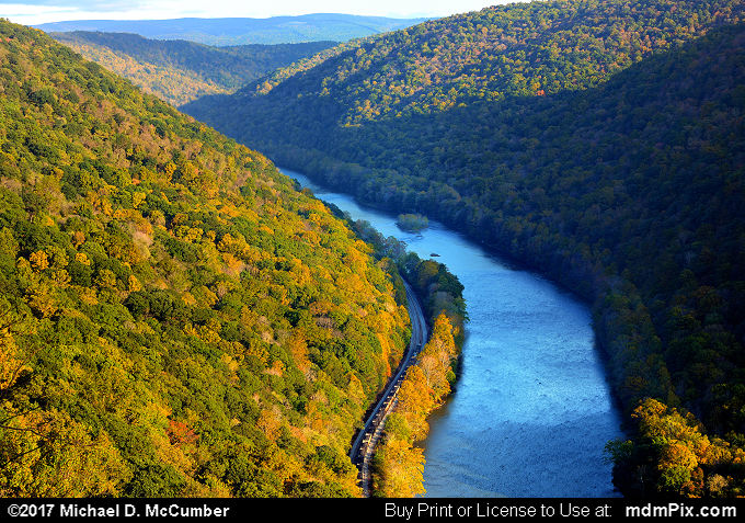
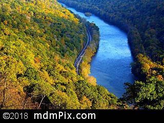
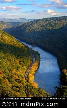
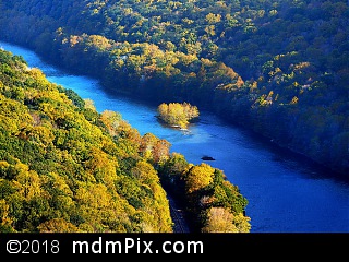
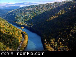
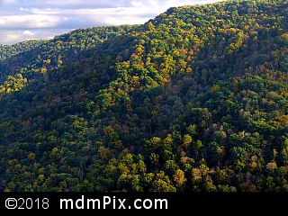
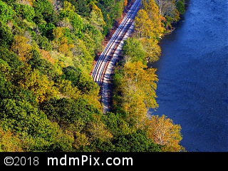
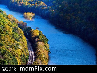
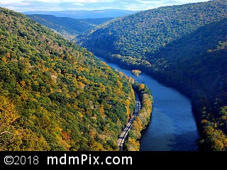
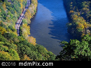
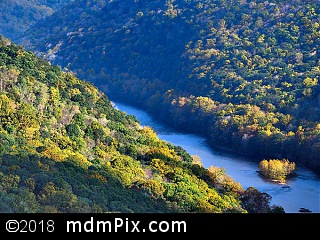
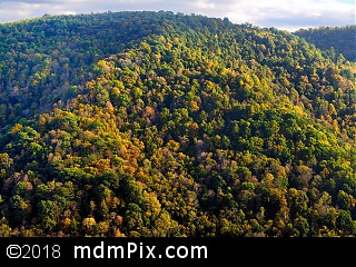
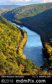
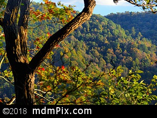
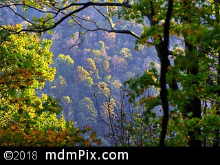
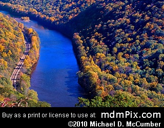
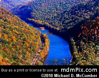
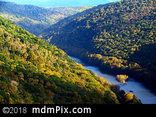
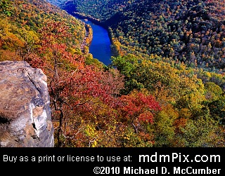
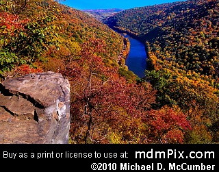
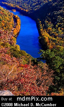
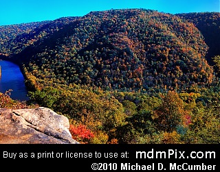
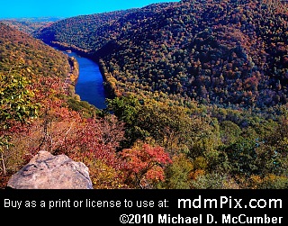
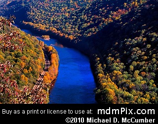
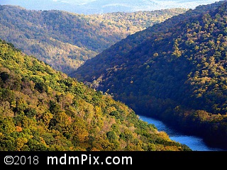
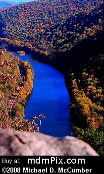
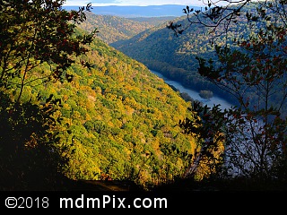
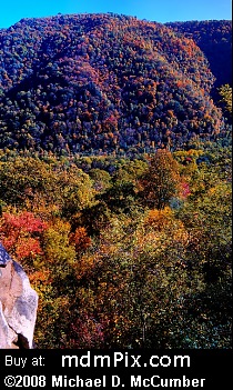
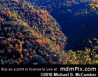
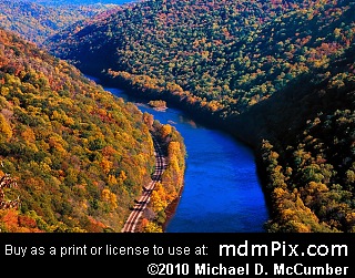
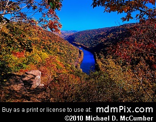
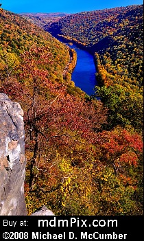
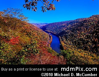
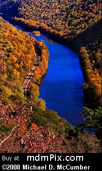
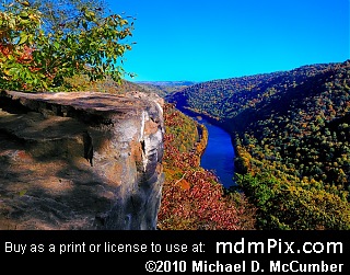
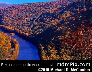
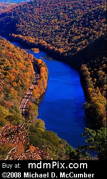
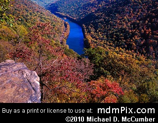
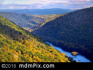
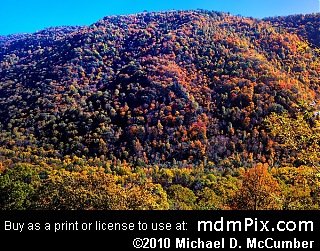
A rock cliff several stories high near the top of Chestnut Ridge and at its Youghiogheny River Water Gap offers one of the best views in western Pennsylvania. It's an amazing sight limited only by the far distant Laurel Ridge over nine miles to the southeast, but in between is the Youghiogheny River nearly eight hundred feet below meandering its way through the deep chasm of its carved gorge in the surrounding terrain. The river itself has what looks like permanent ripples and scars in its otherwise shimmering surface marking the location of its many rapids. A distant island more than a mile away before the river turns out of view can be seen along with the two parallel railroad lines that follow on the northern side of the river's course and feature the occasional train to break the otherwise all natural scene. Beyond that the only signs of man's existence here are distant windmills on the top of Laurel Ridge. Looking directly south is the opposite steep side of Chestnut Ridge, that rises at a 45 degree angle to peak out at nearly 1300 feet above the river, that was cut through by the Youghiogheny River eons ago. It's impressive steep heights with rolling slopes in its side and indentations formed by streams eroding the Youghiogheny Gorge wall is something to admire particularly early or late in the day when the shadows outline the path of each slope. Looking southeast again you can follow the course of the river even beyond what can be seen as its gorge twists amongst the distant hill tops.
A rugged dirt road encased with forest on both sides before brightening at a rise that gives way to a window on the mountain is what the experience is like for those traveling to the Casparis "Lookout Point" Overlook. With trees and vegetation on both sides, at the overlook is a slope leading down to the cliff's edge and a rock ledge that can be carefully followed out for an even better view. At the end of this ledge is a rounded boulder that only the brave may attempt to sit on, but doing so provides a better view of Chestnut Ridge's southern half on the other side of the river. The rock ledge is covered with old graffiti left over from when the area nearby used to be popular for partying, but seems to be slowly eroding back to its natural appearance.
The Lookout Point cliff is so high and the terrain below it so steep that no maintenance is required to keep this vista free of blocking vegetation. Decades ago locals used to actually push vehicles off the cliff and at one time you could see their visible remains rusting away directly below, appearing like the remnants of a junk yard. They're not visible now.
Caution
The road is eroded with rough rocks left exposed. Watch your step. This is particularly the case near the mines where the state came in and blew up the land in front in order to bull doze them shut. The area also has a reputation for snakes so keep a look out. The state bureaucrats in Harrisburg have been battling with the locals to keep them out of their now destroyed (by the state) landmark, the Casparis Mines. The state has signs on the road leading to the overlook with warnings to keep out and no trespassing.
How to Access
You'll find few hikers accessing the overlook as most people use an off-road vehicle to get to it. The rugged dirt road, an offshoot of Casparis Road, leading to it is extremely rocky and rough on the ankles and requires crossing a stream, Laurel Run that is sometimes too high to ford across. Where to begin your hike is another difficulty if you don't have a high profile vehicle. There is no legal parking area to access it from unless you can drive all the way to the top of Chestnut Ridge and park at the State Game Land lot and then walk the rest of the way. With a high terrain vehicle, follow Pittsburgh Street in South Connellsville to the end and turn left onto McCormick Avenue that will bend to the right putting you on Casparis Road. Casparis Road becomes a rough rock road as it ascends up Chestnut Ridge. Once at the top you have a choice of finding a place to park on the side or continue driving. The road will eventually fork, take the right option descending to and crossing Laurel Run and then follow the road back to the parking area for PA State Game Land 51. You'll now be hiking nearly a mile past the former Casparis Mine (destroyed by the state) and then the rest of the way to the overlook.
Get Directions to Parking Using Google Maps:
Adjacent Places
More Information
Near the overlook are several other cliff tops that can offer a good view but are usually obscured by some vegetation. Shortly before Lookout Point is a small trail leading to a rock top that offers a direct view of the Chestnut Ridge cross section on the other side of the river, but mostly obscured by tree branches outside of winter. The lesser one can be accessed by following the dirt road a little bit further, just fifty feet or less, to where you'll see a rock outcropping below you. This also would have the best visibility in winter.
Casparis Lookout Point Overlook is located in Pennsylvania, near South Connellsville, Pennsylvania.
Map for Place