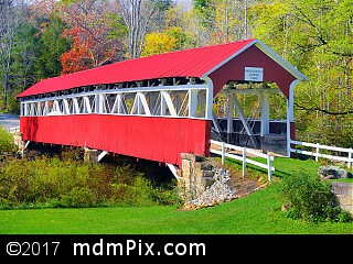
Barronvale Covered Bridge

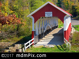
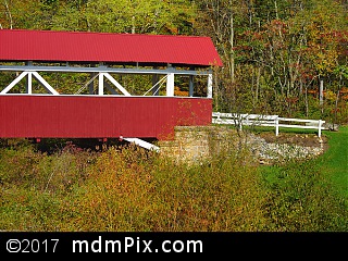
The Barronvale Covered Bridge is a long two span burr truss bridge painted red and white located near the intersection of Read and Covered Bridge Road that crosses Laurel Hill Creek as it exits a remote area of Forbes State Forest. The bridge was likely built in 1902 though other previous dates for the construction are given such as 1832. An alternative name for the bridge is Barron's Mill Bridge. The bridge is open to foot traffic only.
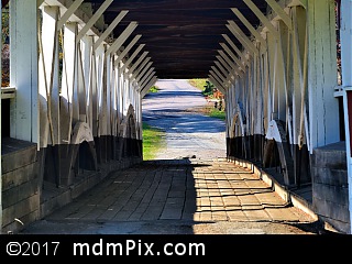
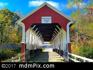
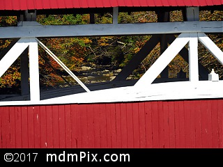
A small parking area on the east side of Laurel Hill Creek leads to a well maintained grassy yard that can be crossed to get a view of the bridge's opening. White split rail fencing leads to the opening and offers protection over the bridge's stone foundation. Entering the bridge beneath the 1832 sign you'll come to appreciate the rounded wood buttresses that lack any modern metal reinforcement giving it a real original feel. Walking through the bridge is like being inside a wooden tunnel with open windows to look out on either side while hearing the sound of Laurel Hill Creek rushing below you. You can't help but feel the bygone era when these bridges were what was necessary to cross the rivers and streams of this region.
While no longer accessible to vehicle traffic, at one time cars did easily cross inside the bridge's 13 feet and 10 inch width. Barronvale Covered Bridge is the longest remaining in Somerset County, Pennsylvania at 162 feet and 3 inches in length that was a necessity in this location as Laurel Hill Creek flows lazily in a wide path in contrast to its more narrow width both to the north and south of this location.
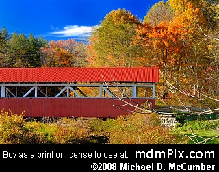
As you exit the bridge and cross up a small path to the left that climbs a little bit higher, you'll be able to turn around and recognize the most common way the bridge is photographed. At this spot you can see the span of the bridge, the opening, and the waters of Laurel Hill Creek below it along with the grassy yard you started from on the opposite shore. This makes for a great picture providing no cars are in view in the small parking area.
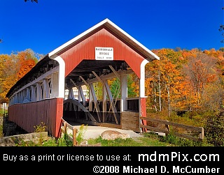
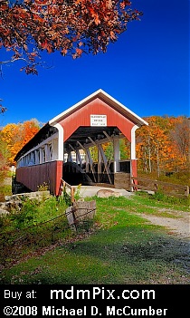
While at this point you could cross back over the bridge, a good vantage point still remains and that is crossing the modern bridge that runs parallel to the covered bridge. With caution to avoid cars, walk around to the road and cross the bridge and about half way you'll have an excellent view of the full span of the Barronvale Covered Bridge with Laurel Hill Creek below and a forest in the background. Then continue crossing the bridge towards the parking area and the last vantage point can be found down in the lower part of the yard giving you a lower vantage point of the bridge.
Caution
The grounds around the covered bridge are privately owned. Please be respectful of no trespassing signs. Be attentive for oncoming traffic when walking on the main road or bridge.
How to Access
From the west, follow Route 653 after descending down from Laurel Ridge to until you make a left onto Covered Bridge Road. Follow that until you arrive at the bridge where you'll find a small parking lot on the opposite side of the creek. From the east, follow Route 653 until you make a right onto Barron Church Road near Scotty Land Campground. Following the campground, make a left into Covered Bridge Road that leads to the bridge.
Get Directions to Parking Using Google Maps:
Adjacent Places
More Information
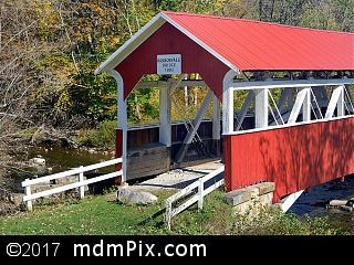
The bridge looks best in autumn when the forest to its north is colored in hues of orange or red, but the red bridge stands out nicely covered in winter snow or even with deep green color of late spring and summer. The covered bridge looks best following a rainy period that raises the water level of Laurel Hill Creek to a point where it covers the areas of sediment along its eastern shore.
Barronvale Covered Bridge is located in Pennsylvania.
Map for Place