Hog Canyon South Rim Overlook Area

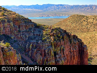
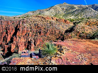
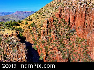
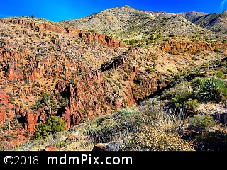
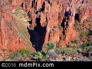
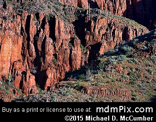
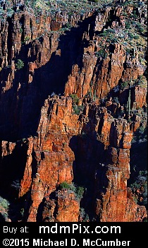
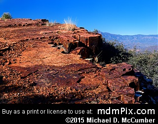
A rust colored rugged landscape that is in transition from desert grasslands to shrubs surrounds you as you explore the relatively flat plateau at the edge of Hog Canyon in the upper foothills of the Sierra Ancha Mountains approximately 34 miles northwest of Globe, AZ. A dirt road connects the two best vantage points with the first being directly forward from the main road where if you continue towards the rim's edge you'll find a rock bluff to stand or sit on to enjoy a view of Hog Canyon opening up to the Salt River Valley below. The wide vista includes a two or three hundred foot cliff leading down into the valley and beyond can be seen a portion of Roosevelt Lake. Far on the opposite side of the valley is Four Peaks Mountain that is over twenty miles away, and as you begin to look more to the right you can see the cliffs rising out of Hog Canyon to an opposite bluff on the north rim with a rugged rocky landscape in between. Turning further right can be seen the nearest mountain peak, Asbestos Point, at over 6600 feet in elevation. Strewn about and around you are plenty of cacti including Ocotillo, Prickly Pear, and smaller ones hiding amongst the grasses. After venturing back to the dirt road, follow it to an obvious point of interest: a flat rock outcrop near the more impressive part of the rim. Once there you'll admire a labyrinth of ragged cliffs and towers of rock, all with a burnt red brick color, below you. From this rock can be enjoyed some of the finest upper Sonoran Desert scenery in all directions. To the right of Asbestos Point is an eye catching slope of broken rock called scree that from the distance can be mistaken for snow. Several prominent scree formations adorn the higher tops of the Sierra Ancha Mountains.
This area is particularly beautiful early in the morning when the low angled sun really brings out the red hues of the Dripping Spring Quartzite Sandstone Rock.
Hog Canyon is the second in a series of prominent folds on the edge of an escarpment along the Sierra Ancha Mountains that are accessible from Route 288, the Globe-Young Highway. First Water Canyon is the lowest in elevation and smallest in size, the fold following Hog Canyon is Parker Canyon that is massive in size and contains the tallest cliffs.
If you cross the terrain from the flat rock outcropping and head towards Asbestos Point you'll eventually lead to what seems like an entrance into the canyon but rock climbing gear would be required as it contains a series of steep drop offs leading down into it.
Occasionally people will park their vehicle in this area to picnic and even camp, enjoying the full panorama of scenery around them. The landscape is incredibly peaceful and at times not a sound can be heard from it in all directions. The peacefulness is awe inspiring.
Caution
Stick to the dirt road and open rock surfaces to avoid the thorny plants and small cacti that hide in grasses. Keep an eye out for snakes. Avoid going near the edges of steep and dangerous cliffs.
How to Access
Follow Route 288 North as it rises steeply out of the Salt River Valley below. The road will bend to the left where you'll pass the "First Water Canyon", following that will be a dirt road on the left at the point where you can see Hog Canyon in the distance. Either park along the entrance of this dirt road or if you have a high profile SUV you can drive on it. It's only a short 600 foot walk from the main road to the rim of Hog Canyon.
Get Directions to Parking Using Google Maps:
Adjacent Places
More Information
Hog Canyon South Rim Overlook Area is located in Arizona.
Map for Place